Ottoman Nautical Charts
2000 TL ve üzeri alışverişlerde kargo ücretsizdir. Ürün Kodu: 3350050Stok : Tükendi
%5 indirimli
114.00 TL
120.00TL
-
Havale %5 + 7 106.02 TL -
Tek Çekim %5 + 4 110.58 TL
Kredi Kartı Tek Çekim (%3) :110.58 TL (KDV Dahil)>
Havale / EFT (%7) :106.02 TL (KDV Dahil)
Bankalara özel taksit seçenekleri :
Havale / EFT (%7) :106.02 TL (KDV Dahil)
Bankalara özel taksit seçenekleri :
| Garanti Bonus Card | ||
| Taksit tutarı | Toplam | |
| 2 | 57.00 TL | 114.00 TL |
| 3 | 38.00 TL | 114.00 TL |
| 6 | 19.00 TL | 114.00 TL |
Bilgi / Telefonla Sipariş0216 392 16 71 - 72

Ottoman Nautical Charts Ürün ÖZELLİKLERİ
Ottoman Nautical Charts The Atlas of Ali Macar Reis
160 Sayfa - 23 x 33 cm
Kemal Özdemir Denizler Kitabevi / Yayınevi Genel Dizisi / İstanbul, 1992
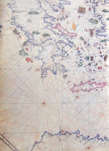
16th century Ottoman nautical charts figure significantly in the history of cartography. Dating from the time when the Ottoman Empire was approaching its zenith of wealth and power, these charts are a valuable source of information about the history of the period. The work of the Ottoman privateers who then held sway over most of the Mediterranean, these charts cover a geographical area far beyond the bounds of the Ottoman Empire. as rulers of an expanding empire, the Ottoman sultans took a close interest in mapmaking and may well have commissioned their sea captains to draw the charts. When Piri Reis presented his first world map to Sultan Selim I, conqueror of Egypt, in 1517, the sultan is said to have declared, "How small is the world for a conqueror.
Diğer İngilizce ürünlerimizi incelemek için kategorimizi ziyaret edebilirsiniz: İngilizce
Tüm tekne ve yat malzemelerini incelemek için tıklayın: Tekne Malzemeleri
ÜRÜNÜN DİĞER ÇEŞİTLERİ - (Ürüne gitmek için resme tıklayınız)
| Kodu | Özellikleri | Stok | Fiyatı |
|---|
İlgili Ürünler